1 Gritstone Moor Nidderdale and Washburn (pdf / 452 KB)
2 Upper Nidderdale Valley Reservoirs (pdf / 631 KB)
3 Upper Nidderdale Valley (pdf / 387 KB)
4 Nidderdale Valley Low Sikes to Pateley Bridge (pdf / 553 KB)
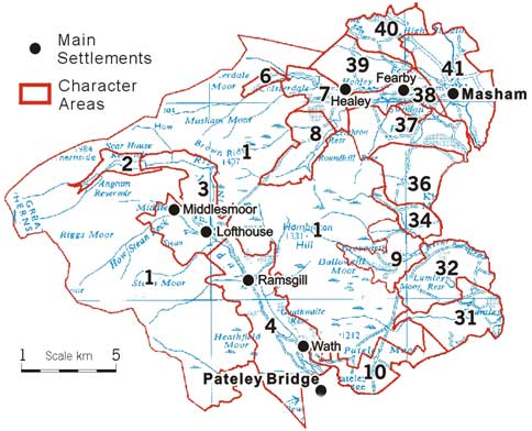
6 Upper Colsterdale Valley (pdf / 516 KB)
7 Upper River Burn to Pott Beck Confluence (pdf / 551 KB)
8 Upper Pott Beck Valley Reservoirs (pdf / 324 KB)
9 Laverton Upland Fringe (pdf / 425 KB)
10 Bishopside Upland Fringe Farmland (pdf / 431 KB)
31 Upper River Skell Valley (pdf / 576 KB)
32 Skelding, Galphay and Lumley Moors Upland Fringe (pdf / 418 KB)
34 Kirkby Malzeard Parliamentary Enclosure (pdf / 544 KB)
36 Grewelthorpe Moor Grassland (pdf / 404 KB)
37 Ilton to Nutwith Wooded Upland Fringe Grassland (pdf / 699 KB)
38 River Burn Valley Farmland (pdf / 528 KB)
39 Ellingstring and Fearby Upland Fringe Grassland (pdf / 497 KB)
40 Ellingstring to Low Ellington Upland Fringe (pdf / 564 KB)
41 River Ure Corridor Charlcot to Aldburgh Hall (pdf / 423 KB)