Online and phone payments Thursday 24 April
Online and phone payments are unavailable between 9am and 5pm on Thursday 24 April. You can make a payment as normal outside of these times.
This area was once a glacial lake. 10,000 years ago trees almost entirely covered the North Yorkshire Moors. Today that cover is around 23% which increases the volume of water arriving downstream. The river is well connected to the groundwater due to the nature of the bedrock and also likely because of the historic path of the watercourse in Norton.
Now the area has fertile silts well suited to agriculture. This is supported by drainage of the land and disconnection from the natural floodplain.
The River Derwent is a main river that drains around two thirds of the North York Moors. It is relatively slow to rise in Malton and Norton, and once groundwater has risen, levels can take a long time to fall. Groundwater can emerge along spring lines, particularly in the Sheepfoot Hill area. When groundwater levels are high and other drainage systems are at capacity, water is also able to enter the combined sewer system.
Before the flood walls were built in 2003, 169 properties were flooded. Building the flood walls has massively reduced the number of properties directly affected by flooding. Although the scheme reduces flood risk from the river, it was not funded to manage surface water and ground water risk.
The creation of the flood defences highlighted the presence of groundwater and surface water.. The area sits on an underground aquifer, which means that during long periods of rain high ground water levels are more likely. Water builds up on the property side of the flood walls and is prevented from draining back into the river by the flood walls. To reduce this risk a pump is used to return the ground water back to the river when levels are high.
In recent years, the following key flooding events have taken place in the area:
Serious river flooding occurred which affected around 169 properties. Modelling suggests that if river defenses were not installed now, around 230 properties would be at risk from river flooding in a high-risk event.
The pump plan was put into action in response to high river and ground water levels, so only a small number of properties were flooded.
During January the river levels were similar to that experienced in 2000. However, the water level did not go over the top of the river defenses which protected a large number of properties from flooding. There were also over 30 temporary pumps operating across the area responding to ground water issues. Flooding did however occur to 14 residential properties and eight businesses.
This winter has seen 13 named storms and it has been the wettest October to March on record nationally. There have been higher-than-average groundwater levels affecting the Sheepfoot Hill of Malton, and continual saturated ground and drainage systems. The River Derwent rose to high levels four times during the winter and remained at a high level for nearly three months. Its highest level was around 4.7 metres, which has been seen three times in the last 12 years. These high water levels led to 19 temporary pumps being put into operation as well the use of Yorkshire Water and the Environment Agency permanent pumping stations.
During 2009 to 2012, the Environment Agency, Ryedale District Council (now North Yorkshire Council) and Yorkshire Water developed the multi-agency pumping plan which has been designed to manage the remaining risks of flooding.
The plan is activated when the river or ground water levels are high, preventing groundwater from draining into the river. Agencies come together during these events to plan where to place the pumps. The plan has proven to be successful over recent years: up to 32 pumps have been put into action at the same time during some of the wettest winters.
Key locations that partners will routinely discuss using the pumps for a limited time are:
Completed around 2003, the flood walls and embankments were installed to prevent river flooding. This has left a risk of groundwater flooding, drainage, and seepage (the movement of water in soils or the ground).
The Environment Agency started a number of projects in 2022 to maintain existing defences and improve the flood risk which is costing around £10 million. Examples of these projects include:
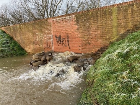
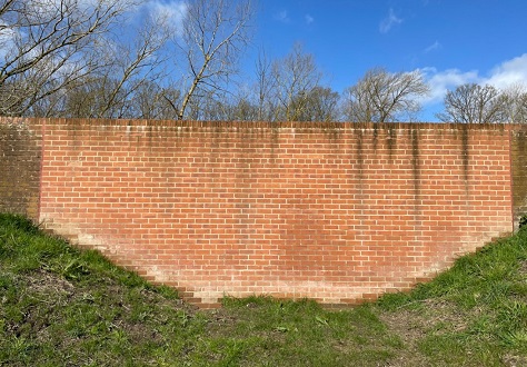
Underground and brick cladding repairs were made to the Wallgate floodwall:
As well as the repair work, routine maintenance is carried out every year, including:
Partners are committed to investing in the area to ensure defenses are maintained and improved where possible. A number of projects are in the first stages of development:
The Environment Agency are working with the Yorkshire Wildlife Trust to deliver a Natural Flood Management project upstream in the River Dove catchment and are also exploring opportunities that might help slow the flow in the catchment.
The Environment Agency is assessing the condition and quality of the river defences after more than 20 years of use to make sure they continue to provide protection for the next 30 years. Current estimates suggest this project may cost between £6 million to £9 million.
There is a project looking at the possibilities of reducing the amount of water that flows over the road at the Castlegate and Sheepfoot Hill junction, which often causes the road to be closed. This work will be carried out later this year.
North Yorkshire Council are looking into the possibility of extending the pipework that goes underground across the end of Church Street. Currently, the Yorkshire Water pump blocks the footpath causing disruption. Extending the pipework underground would prevent the footpath from being closed. However, this will depend on whether there are any other utilities under the path that would be in the way. If the scheme is possible, it is expected that the work will be carried out later in the summer of 2024.
A separate project has also started to review the condition and capacity of two Environment Agency pumping stations in Norton. The work could include refurbishment to the existing arrangements to make them more efficient.
Be prepared for flooding:
It is advisable to also create a flood emergency plan for your family or business.
A drop-in flood hub has been set up by all the partners for those wishing to find out more and discuss flood issues in person.
The hub takes place in the Norton Town Council building:
The Old Courthouse
84B Commercial Street
Norton
YO17 9ES
Meetings will take place on: